> Daily archaeology news from the Internet (on www.archaeologica.org).
> Latest publications : North Africa, Sahara, West Africa - in french
> Latest publications : Central Africa - in french
> African-archaeology.net news archives : 2011 - 2010 - 2008 - 2007 - 2006 -
|
Fish Swam the Sahara, Bolstering Out of Africa Theory (North and West Africa) 28 December 2010 (livescience.com) Fish may have once swum across the Sahara, a finding that could shed light on how humanity made its way out of Africa, researchers said. The cradle of humanity lies south of the Sahara, which begs the question as to how our species made its way past it. The Sahara is the largest hot desert in the world, and would seem a major barrier for any humans striving to migrate off the continent. Scientists have often focused on the Nile Valley as the corridor by which humans left Africa. However, considerable research efforts have failed to uncover evidence for its consistent use by people leaving the continent, and precisely how watery it has been over time is controversial. Now it turns out the Sahara might not have been quite as impassable as once thought — not only for humanity, but for fish as well. "Fish appeared to have swam across the Sahara during its last wet phase sometime between 10,000 and 6,000 years ago," researcher Nick Drake, a geographer at King's College London, told LiveScience. "The Sahara is not a barrier to the migrations of animals and people. Thus it is possible — likely? —that early modern humans did so, and this could explain how we got out of Africa." Using satellite imagery and digital maps of the landscape, the researchers found the Sahara was once covered by a dense network of rivers, lakes and inland deltas. This large waterway channeled water and animals into and across the Sahara during wet, "green" times. [See digital map of ancient Sahara] In their analysis, Drake and his colleagues found evidence that many creatures, including aquatic ones, dispersed across the Sahara recently. For example, 25 North African animal species have populations both north and south of the Sahara with small refuges within the desert, including catfish (Clarias gariepinus), tilapia (Tilapia zillii), jewel cichlid fish (Hemichromis letourneuxi) and freshwater snails such as the red-rimmed melania (Melanoides tuberculata). Indeed, more animals may have once crossed over the Sahara than over the Nile corridor, the researchers said — only nine animal species that occupy the Nile corridor today are also found both north and south of the Sahara. If fish could have crossed the Sahara, it is hard to imagine that humans didn't. Analysis of African languages and artifacts suggest that ancient waterways recently affected how humans occupied the Sahara. For instance, speakers of Nilo-Saharan languages once lived across central and southern Sahara, and may have once hunted aquatic creatures with barbed bone points and fish hooks. In addition, ancient lake sediments suggest the Sahara was green roughly 125,000 years ago, back when anatomically modern humans might have begun migrating out of Africa. Future work could focus on when species got across the Sahara — genetic analysis of fish could help pinpoint such times in fish, Drake said. However, further research into the past of the Sahara could prove difficult and even dangerous, he noted. Some of the Saharan countries the researchers would like to visit in order to analyze the genetics of fish populations or date the ages of ancient shorelines "are deemed to be too dangerous to visit due to terrorist activity or civil war," Drake said. The scientists detailed their findings online Dec. 27 in the journal Proceedings of the National Academy of Sciences. Source : http://www.livescience.com/animals/fish-possibly-swam-across-sahara-101228.html
| |
|
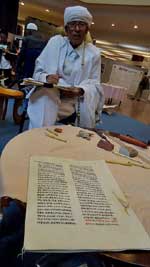
Preserving ancient manuscripts in Africa (Africa & Ethiopia) 19 December 2010 (pasthorizons.com) During a two-day international Conference on Preserving Africa’s Ancient Manuscripts being held in Addis Ababa, Ethiopia, the call was heard for the preservation of Africa’s ancient manuscripts. Deputy Prime Minister and Minister of Foreign Affairs Hailemariam Dessalegn said that although Africa is the poorest continent economically, it has a wealth of cultural heritage. The conference was organised to find ways of preserving Africa’s ancient manuscripts in which past glories and failures, achievements and frustrations are documented. Echoing the current call for the world’s museums to return previously acquired artefacts and historic manuscripts Dessalegn said; “Over the centuries, several European invaders have desecrated, destroyed or looted African treasures. These looted manuscripts have become the main attractions in many European museums and galleries.” “If properly managed, they can be sources of economic development and can also generate income through tourism,” he added. Culture and Tourism minister Amin Abdoulkadir talked on how Ethiopia is endowed with invaluable literary heritages. However he admitted that these archives are often inadequately housed and cared for, adding that many of them are still in the hands of individuals and families and many others are not even identified and registered. Many of them are still in the hands of individuals and families and many others are not even identified and registered Currently only twelve of Ethiopia’s literary documents are registered as world literary heritage by UNESCO. African professional conservators and curators attended the two day forum where they discussed how best to handle Africa’s ancient manuscripts. The forum will also plan how to create a mechanism for wider cooperation which will address the issue at a pan-African level, laying the foundations for a networked support resource. Source : http://www.pasthorizons.com/index.php/archives/12/2010/preserving-ancient-manuscripts-in-africa
|
|
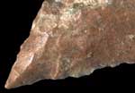
Deep African roots for toolmaking method (South Africa) 20 November 2010 (ScienceNews) Stone-trimming technique originated earlier than thought, archaeologists contend Stone-tool makers living in southern Africa 75,000 years ago pushed the cutting edge in more ways than one. These intrepid folk sharpened the thin tips of heated stone spearheads using a forceful technique previously dated to no more than 20,000 years ago, a new study finds. This stone-tool making method, called pressure flaking, was invented and used sporadically in Africa before spreading to other continents, according to a team led by archaeologist Vincent Mourre of the University of Toulouse-Le Mirail in France. Having a flexible repertoire of tool-making methods aided the survival of modern humans who left Africa beginning around 60,000 years ago, the scientists propose in the Oct. 29 Science. The finding fits with the idea that symbolic art, rituals and other forms of modern human behavior developed gradually over hundreds of thousands of years, not in a burst of cultural innovation marked by cave paintings and other creations that appeared after 50,000 years ago in Western Europe. Excavations of sediment dated to 75,000 years ago in South Africa’s Blombos Cave produced stone artifacts displaying signs of pressure flaking, Mourre and his colleagues say. “The Blombos evidence for pressure flaking is the oldest we know,” says anthropologist and study coauthor Paola Villa of the University of Colorado Museum of Natural History in Boulder. Blombos Cave and nearby sites of comparable age previously yielded engraved pigment chunks (SN Online: 6/12/09), decorated ostrich egg shells (SN: 3/27/10, p. 10) and heat-treated stone artifacts (SN: 9/12/09, p. 15). Southern Africans occasionally made items with symbolic meanings and used special forms of toolmaking beginning 100,000 years ago or more, Villa suspects. These practices flourished in and out of Africa starting about 40,000 years ago, in her view. Pressure flaking consists of trimming the edges of a finished tool by pressing with a bone point hard enough to remove thin slices of rock. This process creates the narrow, evenly spaced grooves found on flint tools from Europe’s 20,000-year-old Solutrean culture and prehistoric Native American groups. Wider, more irregular grooves characterize 36 pressure-flaked Blombos tools, which were made from silcrete, Villa says. This rock, a silica-rich material, is of lower quality than flint and requires heating to ready it for pressure flaking. Villa and her colleagues identified glossy areas on silcrete tools at Blombos that, they surmise, formed when the stones were pre-heated for pressure flaking. Other marks on the artifacts indicated that they had been attached to handles, probably as spearheads. By pressure flaking preheated replicas of the Blombos finds made from silcrete collected near the South African cave, Mourre was able to reproduce marks resembling those on the ancient artifacts. Tool makers likely used pressure flaking by 100,000 years ago in East Africa, remarks archaeologist John Shea of Stony Brook University, New York. Several sites there contain stone artifacts, many made from obsidian, that deserve close analysis for pressure-flaking marks, Shea says. Shea, an expert at making replicas of Stone Age tools, notes that pressure flaking can be taught in 30 minutes to a novice. “It is, literally, so easy a caveman can do it,” he says. Pressure flaking doesn’t add much sharpness or strength to a cutting instrument, Shea adds. Blombos tool makers probably employed this technique to advertise their skill or to denote users’ social identity, he proposes. Archaeologist Curtis Marean of Arizona State University in Tempe calls the evidence for pressure flaking at Blombos “suggestive but not completely convincing.” Further work needs to confirm that pressure flaking of replicated silcrete artifacts consistently produces marks like those on the Blombos finds, Marean asserts. Knowledge of pressure flaking doesn’t imply any special mental or toolmaking abilities, he remarks. Like Shea, Marean regards pressure flaking as a simple way to finish shaping tools made from certain types of stone. “If the authors are correct that pressure flaking occurred at Blombos Cave, the result is important in that that it extends the time range of the technique,” Marean says. “But it’s not game-changing in our understanding of the origins of complex cognition.” Source : http://www.sciencenews.org/view/generic/id/64807/description/Deep_African_roots_for_toolmaking_method
|
|
Ancient African Dust Caused Red Soil in Southern Europe, New Research Reveals (North Africa) 16 November 2010 (ScienceDaily)) Spanish and American researchers have conducted a mineralogical and chemical analysis to ascertain the origin of "terra rossa" soil in the Mediterranean. The results of the study reveal that mineral dust from the African regions of the Sahara and Sahel, which emit between 600 and 700 tonnes of dust a year, brought about the reddish soil in Mediterranean regions such as Majorca (Mallorca) and Sardinia between 12,000 and 25,000 years ago. "The first hint of the relationship between African dust and certain soils in the region of the Mediterranean is their reddish or reddish-brown colour, similar to that of African aerosol filters, caused by their clay content," explained Anna Ávila, co-author of the study and researcher at the Centre for Ecological Research and Forestry Applications (CREAF) at the Universidad Autónoma de Barcelona. The study, which has been published in Quaternary Science Reviews, finds that African mineral dust additions "play an important role" in the origin of the soils (palaeosols) in the Mediterranean region, namely on the island of Majorca. The results resemble those published regarding the soils on Sardinia, "which indicates the likelihood of Africa being a common source." In turn, "African dust explains the origin of the 'terra rossa' soils in the Mediterranean region located on top of mother carbonate rock," Ávila added. In order to explain the origin of the reddish soils, the researchers considered three hypotheses: the non carbonate residual accumulation theory (soils are derived from the product of non carbonate weathering of the mother carbonate rock), the ascending 'sesquioxide' theory (accumulation of iron and aluminium hydroxides following capillary ascent from the bedrock) and the non-native soil accumulation theory (soil is formed by external sources, including airborne contributions). The first two hypotheses were discarded due to the geochemical composition of the trace elements of red soils and the underlying rock being different. "The hypothesis of non-native (external) contribution was reinforced due to the geochemical value of the land coinciding with that of African dust," the scientist stated. However, although the analysis of the soil indicates that African dust is the main contributor to the formation of the palaeosol, "the underlying rock also contributes, probably with residual quartz," the researcher added. Origin and Destination of African Dust "Terra rossa" (red soil in Italian) is located on carbonate rock (with a high content of carbonate) and is spread throughout the Iberian Peninsula, the South of France, the islands in the Mediterranean, Italy and along the coast of the Adriatic Sea, from Slovenia to Greece. The largest sources of airborne mineral dust can be found in the Sahara and Sahel regions, with emissions of between 600 and 700 tonnes per year. The destination of this dust has recently aroused great interest among the scientific community for various reasons. Apart from the formation of red soils, African dust has "adverse effects on human health, such as respiratory problems and reduced visibility. It also arouses interest due to its implications where climate change is concerned, with the role that mineral aerosols play in the radiation balance, nutrient deposition and oceanic fertilisation," Ávila explained. Source : http://www.sciencedaily.com/releases/2010/11/101111082705.htm
|
 |
Human Ancestors Hunted by Prehistoric Beasts (Kenya) 12 October 2010 (Discovery News) THE GIST * Remains of our early primate ancestors suggest birds and mammals often preyed upon our distant relatives. * Predation can affect the behavior, group structure, body size and other characteristics of a species. * Humans today may retain behaviors tied to our ancestors' likely past status as prey rather than predator. Early humans may have evolved as prey animals rather than as predators, suggest the remains of our prehistoric primate ancestors that were devoured by hungry birds and carnivorous mammals. The discovery of multiple de-fleshed, chomped and gnawed bones from the extinct primates, which lived 16 to 20 million years ago on Rusinga Island, Kenya, was announced today at the Society of Vertebrate Paleontology's 70th Anniversary Meeting in Pittsburgh. At least one of the devoured primates, an early ape called Proconsul, is thought to have been an ancestor to both modern humans and chimpanzees. It, and other primates on the island, were also apparently good eats for numerous predators. "I have observed multiple tooth pits and probable beak marks on these fossil primates, which are direct evidence for creodonts and raptors consuming these primates," researcher Kirsten Jenkins told Discovery News. Creodonts were ancient carnivorous mammals that filled a niche similar to that of modern carnivores, but are unrelated to today's meat eaters, she explained. The Rusinga Island creodonts that fed on our primate ancestors were likely wolf-sized. "There is one site on Rusinga Island with multiple Proconsul individuals all together and these are covered in tooth pits," added Jenkins, a University of Minnesota anthropologist. "This kind of site was likely a creodont den or location where prey could be easily acquired." Analysis of tooth pits, de-fleshing marks, bone breakage patterns, gnawing and other damage to the primate bones indicate that raptors were also hunting down these distant relatives of humans. "Primatologists have observed large raptors taking monkeys from trees," Jenkins said. "When a raptor approaches a group of monkeys, those monkeys will make alarm calls to warn their group and attempt to retreat to lower branches. The primates on Rusinga had monkey-like postcrania and likely had very similar locomotor behavior." The study presents the first evidence of raptor predation on fossil primates from Rusinga, which was part of the side of a large volcano 20 million years ago. Multiple ash layers suggest that eruptions killed countless animals from time to time. But when the volcano was inactive, the site supported a wooded area. Jenkins is not certain what selective pressures predators placed on these very early primate ancestors to humans, but she said they "can affect behavior, group structure, body size and ontogeny (the life cycle of a single organism)." Robert Sussman, professor of physical anthropology at Washington University in St. Louis, has long argued that primates, including early humans, evolved not as hunters but as prey of many predators, including wild dogs and cats, hyenas, eagles and crocodiles. "Despite popular theories posed in research papers and popular literature, early man was not an aggressive killer," said Sussman, author of the book "Man the Hunted: Primates, Predators and Human Evolution." "Our intelligence, cooperation and many other features we have as modern humans developed from our attempts to out-smart the predator." He added that the idea of man as hunter "developed from a basic Judeo-Christian ideology of man being inherently evil, aggressive and a natural killer." "In fact, when you really examine the fossil and living non-human primate evidence, that is just not the case," he explained. Jenkins and her colleagues continue to excavate at Rusinga and nearby Mfangano islands, hoping to find more fossils -- especially those from birds -- so that the scientists can identify the species that were hunting the prehistoric primates. Source : http://news.discovery.com/archaeology/human-ancestors-prey-hunted.html
|
|
Study to reveal link between climate and early human evolution, Olduvai Gorge (Kenya) 6 October 2010 (eurekalert) Olduvai Gorge is a steep-sided ravine on the edge of the Serengeti Plain, East Africa, and is home to some of the world's most important fossil hominins. Geologists are investigating the chemical composition of carbonate rocks that lie beneath the surfaces where early human fossils have been uncovered. The data will help an international team of geologists, paleoanthropologists and archaeologists understand how environmental pressures may have influenced the development of human ancestors and their use of the land. Professor Ian Stanistreet, from the School of Environmental Sciences, said: "Research findings so far suggest that environmental changes, such as very dry conditions to very wet, were more extreme and took place more frequently than previously thought. It is currently unclear how these changes might have contributed to human evolution, but evidence indicates that an ability to cope with hostile and rapidly changing environments may have characterised and shaped the development of the human race." The team is investigating elements in the mineral calcium carbonate, which were deposited in the mud and soil in and around a lake between two and 1.7 million years ago. Carbonates formed in the semi-arid environment of the Olduvai Gorge through evaporation and concentration of soil and lake water. The chemical makeup of calcium carbonate mirrors the chemical composition of the water from which it came, allowing scientists to understand what the original soil water was like and what influenced it, such as climate and vegetation growth. Elisabeth Rushworth explains: "We are looking at deposits of calcium carbonates, from the oldest samples to the youngest, over a period of 300,000 years. Geochemical analyses allow us to build a picture of what the environment was like and the kind of land that our ancestors would have lived and worked on." Professor Jim Marshall added: "There are times when the climate was very wet and the soil may show signs of rainwater and at other times there will be traces of water from the lake which was very alkaline. The lake is now extinct, but our ancestors would have depended on the water and vegetation that grew around it. By understanding the chemical signals in the rocks we aim to learn more about the environmental stresses that would have affected our early ancestors." Archeological finds in the Olduvai Gorge include stone tools, and skeletal remains of Homo Habilis and Homo Erectus, as well as bones of, now extinct, wild animals. The Liverpool team's research is funded by the Leakey Foundation, the National Environment Research Council (NERC), and the International Association of Sedimentologists. The Olduvai Landscape and Paleo-anthropology Project (OLAPP) includes scientists from institutions in the UK, US, Tanzania, South Africa, Germany and Spain. Notes to editors: 1. The University of Liverpool is a member of the Russell Group of leading research-intensive institutions in the UK. It attracts collaborative and contract research commissions from a wide range of national and international organisations valued at more than £98 million annually. 2. Founded in 1968, The Leakey Foundation's mission is to increase scientific knowledge, education, and public understanding of human origins, evolution, behavior, and survival. The Foundation awards an average of $600,000, annually in general research grants, though two granting sessions. www.leakeyfoundation.org Source : http://www.eurekalert.org/pub_releases/2010-10/uol-str_1100610.php
| |
 |
Stone tools 'change migration story' (Arabian Peninsula and India) A research team reports new findings of stone age tools that suggest humans came "out of Africa" by land earlier than has been thought. 19 September 2010 (BBC News) Geneticists estimate that migration from Africa to South-East Asia and Australia took place as recently as 60,000 years ago. But Dr Michael Petraglia, of Oxford University, and colleagues say stone artefacts found in the Arabian Peninsula and India point to an exodus starting about 70,000 to 80,000 years ago - and perhaps even earlier. Petraglia, whose co-workers include Australian and Indian researchers, presented his ideas at the British Science Festival, which is hosted this year at Aston University. "I believe that multiple populations came out of Africa in the period between 120,000 and 70,000 years ago," he said. "Our evidence is stone tools that we can date." Most of the tools are from far inland - hundreds of kilometres from the coasts. This means it was more likely humans migrated by land than in boats, he said. The tools are found in areas that are often very inhospitable now, but which at the time would have been much more conducive to migration. "During the period we're talking about, the environments were actually very hospitable," he told BBC News. "So where there are deserts today, there used to be lakes and rivers, and there was an abundance of plants and animals." The team found the stone tools - ranging from a couple of centimetres to nearly 10cm in size - in layers of sediment that they can date using sand and volcanic material found above and below the implements. The tools were mainly either spear heads or scrapers. Dig site (Petraglia et al) Most dig sites are inland In particular, some tools were sandwiched in ash from the famous Toba eruption that geologists can date very accurately to 74,000 years ago. Other species of early humans clearly left Africa before our species (Homo sapiens), but Dr Petraglia's team thinks that the tools it has found are the type made by modern humans - and not those of Neanderthals, for instance. Previous research has leaned heavily on examining the genetics of different modern populations to find out how long ago they shared a common ancestor - their African common ancestor. Professor Chris Stringer, of the Natural History Museum in London, said this genetic data showed humans left Africa around 60,000 years ago or even more recently. He agreed that "these tools show that people were in these regions, but the genetic data show an exit from Africa of later than 60,000 years ago. The people in India could have died out." Dr Petraglia, however, suggested that researching these migrations using population genetics might not lead to accurate results, because all of the genetic studies were based on today's people. The absence of ancient DNA to make additional tests made this area of investigation much less reliable, he claimed. Dr Petraglia's team now hopes to continue its excavations in the region. "We have literally hundreds of projects in Europe and a handful in the Arabian-South Asian belt," he said. Source : http://www.bbc.co.uk/news/science-environment-11327442
|
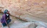 |
UK archaeologist finds cave paintings at 100 new African sites (Somaliland) 17 September 2010 (guardian.co.uk) A local team headed by Dr Sada Mire, of the Institute of Archaeology at University College London (UCL), made the finds, which include a man on horseback, painted around 4,000 years ago – one of the earliest known depictions of a mounted hunter. Leaping antelopes, prancing giraffes and snakes poised to strike are among animals and reptiles depicted with astonishing clarity. Such is the quality of the paintings that at least 10 sites, scattered across semi-desert terrain, are likely to be given World Heritage status. Mire, who has just become a UN consultant for Somaliland, said: "These are among the best prehistoric paintings in the world. "Yet Somaliland is a country whose history is totally hidden. With wars, droughts and piracy in Somalia, hardly anyone has researched the archaeology until now. But it's absolutely full of extraordinarily well-preserved rock art." Dhambalin, about 40 miles from the Red Sea, features horned cattle, sheep and goats painted about 5,000 years ago. The animals have distinctive bands around their backs and bellies, which suggests farming or ritual traditions. The pictures also depict animals, such as giraffes, no longer found in Somaliland. Mire, who is Somali-born, has been struck by paintings of "eerie headless creatures". She said: "Sometimes the cattle are represented as necks or horns, a pictorial shorthand that was evidently sufficient to convey meaning." Other paintings are more mysterious, such as the 2,000-year-old colourful images of the full moon, half-moon and geometric signs at Dawa'aleh. Mire believes these depict the ancient artists' view of the world, time and space. Somaliland is in the northern part of Somalia, an area slightly larger than England but with a population of just 3.5m. More than half are nomads. Once part of the Ottoman Empire, it was a British colony from 1884 until 1960. Although it declared itself independent of Somalia in 1991 and has a separate government, it is yet to be recognised as a separate state. Mire said: "Whereas Somalia has suffered with an ongoing civil war and piracy, Somaliland has remained peaceful. "Yet despite boasting a stable, grass-roots democracy, the country has not been recognised by the UN and so does not formally exist, leaving it a breakaway state teetering on the edge of a violent region. The discovery of the 100 sites follows that of cave paintings at Laas Geel in 2000. For centuries, they were known only to nomads, who believed the site was haunted by evil spirits. Mire's research study will be published this month in Current World Archaeology. Source : http://www.guardian.co.uk/world/2010/sep/17/cave-paintings-found-in-somaliland
|
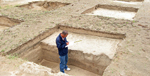 |
National Museums Defends the Digging Up of Ancient Kingdom (Kenya) 13 September 2010 (allafrica) Nairobi — The National Museums of Kenya has defended archaeological work to locate the ancient settlement of Malindi Kingdom. A press release by the joint Sino-Kenya archaeological team said digging at the ancient sites in Mambrui Village in Magarini District was legal and all procedures had been followed. The head of the Chinese team, Prof Qin Dashu and his Kenyan counterpart, Dr Herman Kiriama of the NMK, said the sites were selected on the recommendations of Kenyan scholars. Human skeletons "The sites are not in the burial sections and the team tried to strictly adhere to Islamic laws where graves are not supposed to be tampered with nor bodies or human skeletons exhumed. "This has been observed to prevent damaging both ancient and contemporary graves in accordance with Islamic traditions," the statement said. The statement was issued following what the archaeologists said were negative media reports quoting the Mambrui community that the excavation was being done in disregard of Islamic traditions. The team leaders said the National Museums of Kenya and the Chinese archaeologists consulted widely before starting work and hired 51 youths from Mambrui to help in the excavation. "The excavation has the approval of local elders and government officials in Malindi and Magarini districts. "The exercise has come to an end and the team is consolidating the materials and information collected for analysis. Once the findings are out, the archaeologists will share the information with the public," the statement said. From the initial findings, the archaeologists have concluded that Mambrui has a long and rich history with evidence that the settlement traded with the Middle East and Asia. The archaeologists say the history of the East African coast could be re-written after a three-year excavation on the mainland and Lamu, where a Chinese ship sank some 600 years ago, is concluded. While little is known about Chinese involvement in early trade with East Africa, the excavations could change the perception that Europeans were the first foreign visitors to Africa. Source : http://allafrica.com/stories/201009140114.html
|
 |
BP well threatens ancient Libyan sites (Lybia) 12 September 2010 (independent.co.uk) Plans by the energy giant BP to sink an oil well off the Libyan coast could have disastrous consequences for the region's rich heritage of coastal ancient city sites and shipwrecks – already under threat from oil tankers, coastal erosion and tourist developments – archaeologists from around the world have warned. The energy company has been under increased scrutiny following the leak from its well in the Gulf of Mexico earlier this year which spewed oil for three months in the world's worst maritime spill. Last week a report into the blowout from BP blamed a "complex and interlinked" series of events, including human errors and mechanical failures, for the explosion that killed 11 engineers and led to the spill. BP has, however, announced that it intends to go ahead with plans to sink a well – which would be 200m deeper than the one in the Gulf of Mexico – around 125 miles off the coast of Libya. Work is due to begin before the end of the year. Archaeologists fear that an oil spill in the region could destroy the area's numerous ancient coastal and underwater sites and that thousands of historic shipwrecks could be at additional risk from drilling activity. These include the ancient harbour town of Apollonia, in Cyrenaica – which dates from the 7th century BC and is five metres below sea level – along with two ancient cities in the region of Tripolitania, both of which are World Heritage Sites. Claude Sintes, the director of the Museum of Ancient Arles in the south of France and director of the sub-aquatic team of the French archaeological mission to Libya, said that the sites are either on the beaches or underwater close to the shore. Washed-up oil would soak the porous stone and be impossible to clean, he added. "They are very important sites and they are very fragile," he said. "If there is a problem with oil, like in the US, and it washes on to the shore it's going to be very difficult to clean the remains because the stones are porous. Apollonia is five metres under the water, and is complete with streets and buildings. In Tripolitania there are two important sites, Leptis Magna, a former Roman city, and Sabratha, where there is a theatre and mosaics. Some remains are on the beach and, if there was a leak, oil could wash up and certainly cause problems." Paul Bennett, head of mission for the Society of Libyan Studies, which oversees British archaeological expeditions to the country, agreed that an oil spill would be disastrous for the coastal sites. He added, however, that the area contains tens of thousands of wrecks from the Roman period, and that an opportunity to map the seabed using data collected by BP and other oil companies is being lost – along with the opportunity to ensure the wrecks aren't damaged by seismic surveying or drilling. "If there was the kind of impact assessment you'd expect in European countries, we could see where these wrecks were," he said. "We should be taking advantage of the data collected to map the seabed. There must be tens of thousands of wrecks off the Libyan coast. We'd then be in a position to advise, to ensure they weren't damaged." Steven Anthony, President of the Maritime Archaeological and Historical Society in Washington DC, added that the wrecks – described as "time capsules" – could also be at risk from a potential spill. "There needs to be more research of what happens to spilled oil before drilling begins," he said. "The oil industry and BP say that leaked oil floats. But in the Gulf of Mexico oil was observed in great clouds near the bottom of the sea. "It has happened before and will happen again, sooner or later. There isn't enough information on what happens to the oil after it leaks, or how to remedy it. When the spill in the Gulf happened, it created a lot of discussion between archaeologists about the potential problems. The oil industry needs to invest more." Dr Nic Flemming, a British archaeologist who first mapped Apollonia as a student in 1958, said, however, that the possibility of an oil spill ranked low among his concerns regarding dangers to ancient sites. "It's a problem, but I would say it's 17th of a host of problems," he said. "Tankers already pump out bilge; there are already oil platforms; and ancient sites are being bulldozed because their coastal locations are so valuable. Countries sign up to protection treaties, but if somebody comes along with a lot of money and says 'I want to build a hotel that will create so many jobs', then the treaties are forgotten. "I'm horrified by the changes over the past 30 years," he added. "I remember watching a town being bulldozed into the sea, complete with columns and mosaics, to make way for a new holiday resort. I hardly dare go to look at a site any more." A BP spokesman said drilling will start later this year, adding that any leaked oil would float and that a full seismic survey had been carried out. He said plans for Libya had been reviewed in the aftermath of the Gulf of Mexico leak. Source : http://www.independent.co.uk/news/science/archaeology/news/bp-well-threatens-ancient-libyan-sites-2077153.html
|
|
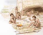
Ancient African Cocktail: Beer and a Shot of Antibiotic (Egypt) 9 September 2010 (livescience) About 1,500 years before the modern world discovered the antibiotic tetracycline, North Africans were fermenting and consuming it, probably for most of their lives, according to a chemical analysis of the bones of people who lived along the Nile. The ancient human remains were recovered near the Sudanese-Egyptian border, where species of tetracycline-producing bacteria inhabit the soil. This region, in Northeastern Africa, was once known as Nubia. Much of it is was flooded when the Nile River was dammed. The practice of brewing beer was widespread in the region, including in Ancient Egypt to the north, and the researchers think the Nubians fermented Streptomyces or related species with their grain to brew a thick, sour beer spiked with tetracycline. And everyone, from about 2 years old and up, consumed it. The researchers suspect the Nubians added the bacteria knowing its benefits, though they likely didn't realize the compounds were antibiotics. "It wasn't a one-time event, because it was all throughout their bones," said Mark Nelson, senior director of chemistry at Paratek Pharmaceuticals, Inc., and an expert in tetracyclines. He performed the chemical analysis on bones from several individuals, which revealed significant amounts of tetracycline. Ancient medicine This finding has been decades in the making. The first evidence emerged in 1975, when George Armelagos, now a professor of anthropology at Emory University, was studying the bones and found that under ultraviolet light, a fluorescent yellow-green band appeared on the bones. The phenomenon was known to be evidence of exposure to tetracycline among modern people, but at first Armelagos dismissed it. A few years later, a graduate student of Armelagos saw the same fluorescent band on bones from the ancient Nubians, and pointed out that tetracycline is a naturally-derived drug. That's when Armelagos realized he had seen what could be evidence of ancient antibiotic use. "My heart stopped," said Armelagos. "It's like if you were unwrapping a mummy and you saw Ray-Ban sunglasses." The modern world discovered tetracycline in 1948, about 20 years after the first antibiotic, penicillin, was isolated, according to Nelson, an editor of "Tetracyclines in Biology, Chemistry and Medicine" (Birkhäuser Basel, 2002). After years of searching soils for micro-organisms that produced compounds toxic to disease-causing bacteria but safe for humans, a soils microbiologist named William Albrecht found a bronze-colored colony of bacteria in a Missouri hay field. Dubbed Streptomyces aureofaciens, it yielded the first tetracycline, called auereomycin, which, to researchers' delight, inhibited the growth of a wide range of bacteria. Auereomycin became the first broad-spectrum antibiotic, according to Nelson. But Armelagos' initial report, in 1981, that these ancient Nubians may have intentionally used tetracycline, sparked controversy, he said. Critics claimed the yellow-green label originated after the people died, as the result of decay. Armelagos said attempts to extract the tetracycline from the remains were unsuccessful, until Nelson offered to help out. Nelson, a medicinal chemist, used a colorless, poisonous, and highly corrosive acid – hydrogen fluoride – to dissolve the bones and essentially extract the tetracycline to prove it was the source of the label. "This is the first real, definitive demonstration that this is tetracycline," Armelagos said. Not in your liquor store There was also the question of whether these people intended to consume the tetracycline, or if the label came from moldy grain eaten out of necessity. "When we first found this, I just assumed that they were consuming this as a famine food," Armelagos said. But he has found that 90 percent of this group of Nubians had bones labeled with tetracycline, and that the evidence for the antibiotic was so extensive that the exposure was unlikely to have been accidental. The ancient Egyptian practice of brewing beer, documented through archeology and ancient art, is believed to have been a long-standing practice in the region at the time. Brewing beer using fermentation mixtures containing Streptomyces, which excrete tetracycline, appeared to be the only way these people could have produced the quantity of the antibiotic necessary to explain the fluorescent signal, according to Armelagos. So they likely intentionally added the bacteria to their fermenting brews. Evidence of tetracycline, though in smaller amounts, has also been found in Egyptians, Jordanians and Christians to the south, he said. In addition to producing an alcoholic buzz, this ancient beer spiked with tetracycline would have cleared up bacterial infections and their symptoms, like diarrhea, as well as killed off harmful bacteria in the brew. Although it's not yet clear how much tetracycline the people consumed regularly – Armelagos thinks it's more than the dosage required to prevent acne – it appeared to have some side effects, including reducing bone loss among older women and increasing iron-deficiency. The brew would not be appealing to modern beer drinkers. "We talk about this as a beer; it's not a Heineken or Bud Light," he said. Armelagos had his graduate student brew it once, describing the result as a sour porridge. "They said it's not bad. That's, I think, the best you can say about it," Armelagos said. Their work was published in the September issue of the American Journal of Physical Anthropology. Source : http://www.livescience.com/health/ancient-nubians-fermented-antibiotics-with-alcohol-100909.html
| |
 |
Desert Roads Lead to Discovery in Egypt (Egypt) 6 September 2010 (nytimes) Over the last two decades, John Coleman Darnell and his wife, Deborah, hiked and drove caravan tracks west of the Nile from the monuments of Thebes, at present-day Luxor. These and other desolate roads, beaten hard by millennial human and donkey traffic, only seemed to lead to nowhere. In the practice of what they call desert-road archaeology, the Darnells found pottery and ruins where soldiers, merchants and other travelers camped in the time of the pharaohs. On a limestone cliff at a crossroads, they came upon a tableau of scenes and symbols, some of the earliest documentation of Egyptian history. Elsewhere, they discovered inscriptions considered to be one of the first examples of alphabetic writing. The explorations of the Theban Desert Road Survey, a Yale University project co-directed by the Darnells, called attention to the previously underappreciated significance of caravan routes and oasis settlements in Egyptian antiquity. And two weeks ago, the Egyptian government announced what may be the survey’s most spectacular find. Zahi Hawass, secretary general of the Supreme Council of Antiquities, said the archaeologists had uncovered extensive remains of a settlement — apparently an administrative, economic and military center — that flourished more than 3,500 years ago in the western desert 110 miles west of Luxor and 300 miles south of Cairo. No such urban center so early in history had ever been found in the forbidding desert. Dr. John Darnell, a professor of Egyptology at Yale, said in an interview last week that the discovery could rewrite the history of a little-known period in Egypt’s past and the role played by desert oases, those islands of springs and palms and fertility, in the civilization’s revival from a dark crisis. Other archaeologists not involved in the research said the findings were impressive and, once a more detailed formal report is published, will be sure to stir scholars’ stew pots. The 218-acre site is at Kharga Oasis, a string of well-watered areas in a 60-mile-long north-south depression in the limestone plateau that spreads across the desert. The oasis is at the terminus of the ancient Girga Road from Thebes and its intersection with other roads from the north and the south. A decade ago, the Darnells spotted hints of an outpost from the time of Persian rule in the sixth century B.C. at the oasis in the vicinity of a temple. “A temple wouldn’t be where it was if this area hadn’t been of some strategic importance,” Ms. Darnell, also trained in Egyptology, said in an interview. Then she began picking up pieces of pottery predating the temple. Some ceramics were imports from the Nile Valley or as far away as Nubia, south of Egypt, but many were local products. Evidence of “really large-scale ceramic production,” Ms. Darnell noted, “is something you wouldn’t find unless there was a settlement here with a permanent population, not just seasonal and temporary.” It was in 2005 that the Darnells and their team began collecting the evidence that they were on to an important discovery: remains of mud-brick walls, grindstones, baking ovens and heaps of fire ash and broken bread molds. Describing the half-ton of bakery artifacts that has been collected, as well as signs of a military garrison, Dr. Darnell said the settlement was “baking enough bread to feed an army, literally.” This inspired the name for the site, Umm Mawagir. The Arabic phrase means “mother of bread molds.” In addition, Dr. Darnell said, the team found traces of what is probably an administrative building, grain silos, storerooms and artisan workshops and the foundations of many unidentified structures. The inhabitants, probably a few thousand people, presumably grew their own grain, and the variety of pottery attested to trade relations over a wide region. Umm Mawagir’s heyday apparently extended from 1650 B.C. to 1550 B.C., nearly a thousand years after the construction of the Great Pyramid at Giza and another thousand before any previously known major occupation at Kharga Oasis. “Now we know there’s something big at Kharga, and it’s really exciting,” Dr. Darnell said. “The desert was not a no man’s land, not the wild west. It was wild, but it wasn’t disorganized. If you wanted to engage in trade in the western desert, you had to deal with the people at Kharga Oasis.” Finding an apparently robust community as a hub of major caravan routes, Dr. Darnell said, should “help us reconstruct a more elaborate and detailed picture of Egypt during an intermediate period” after the so-called Middle Kingdom and just before the rise of the New Kingdom. At this time, Egypt was in turmoil. The Hyksos invaders from southwest Asia held the Nile Delta and much of the north, and a wealthy Nubian kingdom at Kerma, on the Upper Nile, encroached from the south. Caught in the middle, the rulers at Thebes struggled to hold on and eventually prevail. They were succeeded by some of Egypt’s most celebrated pharaohs, such notables as Hatshepsut, Amenhotep III and Ramses II. The new research, Dr. Darnell said, “completely explains the rise and importance of Thebes.” From there rulers commanded the shortest route from the Nile west to desert oases and also the shortest eastern road to the Red Sea. Inscriptions from about 2000 B.C. show that a Theban ruler, most likely Mentuhotep II, annexed both the western oasis region and northern Nubia. With further investigations at Umm Mawagir, Dr. Darnell said, scholars may recognize the desert as a kind of fourth power, in addition to the Hyksos, Nubians and Thebans, in the political equation in those uncertain times. It was perhaps their control of desert roads and alliance with vibrant oasis communities that gave the Thebans an edge in the struggle to control Egypt’s future. In any case, the ruins at a desert crossroads are another wonder of the ancient world. “People always marvel at the great monuments of the Nile Valley and the incredible architectural feats they see there,” Dr. Darnell said in the Yale alumni magazine. “But I think they should realize how much more work went into developing Kharga Oasis in one of the harshest, driest deserts on Earth.” Source : http://www.nytimes.com/2010/09/07/science/07archeo.html?_r=1
|
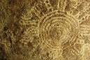 |
Nyero Rock Paintings Destroyed (Uganda) 19 May 2010 Kampala — The architects of the paintings remain as mysterious as the time they were painted, but one thing is certain - they already existed when the Iteso, the present-day inhabitants of the region, arrived in the area about 300 years ago. The skill in which they were painted demonstrates a high degree of appreciation of their artistic values. Archaeologists say the site is of a Later Iron Age period. The Nyero Rock Paintings, with three-tiered rock-shelters, and primitive paintings on their inner surfaces, is one of the many UNESCO World Heritage sites. But, today are fears rife that these famous ancient sites in Kumi district, eastern Uganda will be no more in few years to come if nothing is done to protect them. Jacqueline Nyiracyiza, an official from the Uganda Department of Museums and Monuments, says illegal stone quarrying, charcoal burning and smearing with oil, reportedly for ritual purposes is a big threat to this historical site. She says they will be very difficult to restore. There are 3 different sites: Site 1 has some damage. Some paintings have been scrubbed away. The site was initially protected by a wall which is now half demolished. Site 2, the main site, also called Osigiri, is the most impressive, with a huge rock face covered in red painted circles, what look like two men in a boat and possibly seed pods and animals. Site 3, also known as Otwalaimula, is a few hundred metres north. Here the modest paintings are not easy to notice unless someone shows you. They are only viewed by getting on your back and looking up at the ceiling of the cave. The white circles look like a sun, or moon with legs "Unless we stop stone quarrying, charcoal burning and the use of oil in Nyero rock, there will be no tourists," she says. Nyiracyiza made these remarks on Thursday May 13, during the launch of an exhibition of Africa's unique rock art heritage at Moru-Ikara Primary School in Kumi district. The two-week exhibition was organised by the Department of Museums and Monuments in conjunction with Trust for African Rock Art (TARA) aimed at working with local communities to preserve this cultural heritage. Origins of painting unknown The rock paintings, believed to be the only known stone age rock paintings in Africa, are shrouded by mystery. They are inscribed in red, white and purple pigments. Erimano Ikara, 80, the former caretaker of the rocks for 27 years (from 1966 to 1993) claims they were drawn by the ancient yellow hairy bushmen who lived at that time. The paintings are a silent voice seemingly telling a story about the life, tradition and values of our ancestors. "Those people seemed to have been fishermen and hunters, because some of the paintings have drawings of men sailing in a boat and wild animals like zebras and giraffes," says Ikara. Who discovered the rocks? Elderly women used to go pounding their potatoes inside the caves on hot days in the early 1950s. It is believed these were the first people to see the painting, Ikara says. Some white men used to go to the area to pick flowers. As they kept visiting the rocks, the women showed them the paintings. It did not take long before another group of Americans came. "When these Americans came, they surveyed the place and started excavating the rock. Local people were chased away during the second week of the excavation. We saw them go away with glittering things filled in a sugar bag," says Ikara. Later, when the community went to check the excavated area, they found the stones had not been tampered with. National heritage "In 1962, we heard that the Government was going to fence off the rock. This was done in 1966 and I was recruited as the caretaker by the culture ministry," says Ikara. As Ikara was digging holes for the fence, he unearthed a human hand (from the elbow up to the fingers) which his colleague smashed. He says the place was a habitation for traditional herbalists, who took demon-possessed people for 'healing' by performing rituals and prescribing traditional medicine for them. The site abandoned It is difficult to understand why the artists painted and engraved pictures on these rocks. As a national asset, Nyero is a beautiful place with gigantic rocks balanced on each other. It is also a sacred place where some local religious groups hold ceremonies. However, Nyiracyiza says visitors now find piles of granite chips everywhere, giving the impression of stone quarrying taking place in this sacred or cultural site. Many of the paintings have been covered by graffiti, people scrawling their names, dates and messages. The Otwalaimula site, which is engraved with white centric and was once believed to have been used by medicine men for rain making, is now covered with modern graffiti. The locals are using fire to destroy rocks and boulders that have been there for millions of years. Some of these rocks are adorned with paintings. Struggle to survive Such activities have seriously scarred the natural and the cultural landscape of this exceptional area and have destroyed large quantities of priceless archaeological material. "We have not seen the benefit of that rock at all. How can they say that we should not break the stones and yet we need to eat. If they want their paintings, they should take them away and leave us with those that don't have the paintings," says Sam Omaje. He says it is through stone quarrying and the burning of charcoal that they get money to send their children to school and feed themselves. "Our mission is to create greater global awareness of the importance and endangered state of Africa's rock art. We need to survey sites, monitor their status, be an information resource and promote and support rock art conservation measures," says Gloria Borona, an official from TARA. An official historical site? Rose Mwanja, the acting commissioner, Museums and Monuments in the tourism ministry, says Nyero was gazzetted as a national monument in 1972. "We have historical sites in Karamoja, Katakwi, Kapir, Ngora and Mukongoro (all in Kumi), but Nyero is one of its kind and we should preserve it," she says. She adds that the community is key in the preservation of such sites. She says the white engravings on site three depict the bright sunshine in Uganda. Ismail Orot, the LC5 chairman for Kumi, says the paintings are a sign that as early as as four hundred years ago, the Iteso knew how to read and write. Similar paintings have been found in the southern Africa, lending credence to the ancient population migrations. Lawrence Esiagu, the retired senior cultural officer for Kumi, says Nyero is used as a study centre by scholars and scientists. Concerning the origins of the painting, he says: "The paintings are not from the Iteso. They are believed to have been drawn by people who had yellow skins." William Opio Ilakut, the current caretaker, says the lack of facilities like accommodation and hotels scare tourists away. Officiating at the function, Rev Fr. Simon Lokodo, the state minister for industry, appealed to the people of Nyero to guard the heritage if they are to get revenue from it. He says once the heritage is well protected, more visitors from all over the world will be attracted to Nyero and the proceeds will assist in developing the area. "This heritage should not be left to disappear because it helps us interpret the past. We need our past in order to enjoy the present and to build the future," Lokodo says. He says the Government will take charge of the heritage by introducing a number of social facilities that can attract the tourists and urged the leaders to create awareness of the importance of the heritage. Source : http://allafrica.com/stories/201005200086.html
|
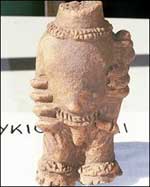 |
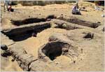
Ghana dig reveals ancient society (Ghana) 16 February 2010 Archaeologists have unearthed dozens of clay figures in Ghana, shedding light on a sophisticated society which existed before the arrival of Islam. Experts from the University of Ghana found 80 sculptures believed to be between 800 and 1,400 years old. They believe the figures, depicting animal and human forms, are part of a burial ground or shrine. Archaeologists say the societies that constructed the figures simply disappeared when Islam arrived. "What is interesting is that the people now living in this area seem to have no connection with the makers of the figurines," said the university's Benjamin Kankpeyeng. "That would suggest that that they have more in common with peoples living in other parts of West Africa - but we need to do more work before we can be certain." Arab slave theory The statues were found amid hundreds of mounds in a densely packed 30km-square area. Mr Kankpeyeng intends to analyse the position and arrangement of the statues with Tim Insoll from the UK's Manchester University. Mr Insoll told the BBC very little was known about civilisations in the area between 600 and 1200 AD because no written history was kept and the societies ceased to exist when Islam arrived. He said experts still did not know why the civilisations came to an end - whether the people converted en masse to Islam, or were captured by Arab slave traders. The statues, he said, could tell historians what kind of people inhabited West Africa in that time. "Figures have been found in this area before, but what we can do with the latest find is map their arrangement to find out what their purpose was - whether for sacrifice or some other ritual," he said. The northern Ghana site, near the village of Yikpabongo, was first excavated in 1985, and the dig was restarted in 2007. The latest batch of figures was discovered in January. Source : http://news.bbc.co.uk/2/hi/africa/8518185.stm
|